Distrito de Chandauli
Chandauli (en hindi; चंदौली ज़िला, urdu; چندولی ضلع) es un distrito de India en el estado de Uttar Pradesh. Código ISO: IN.UP.CD.[2]
| Chandauli | ||
|---|---|---|
| Distrito | ||
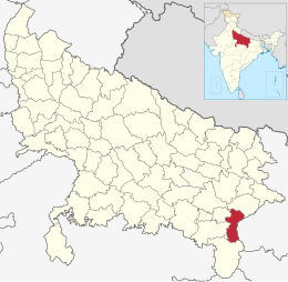
 Ubicación del distrito de Chandauli en Uttar Pradesh. | ||
| Coordenadas | 25°15′41″N 83°15′51″E / 25.261344444444, 83.264080555556 | |
| Capital | Chandauli | |
| Entidad | Distrito | |
| • País |
| |
| • Estado | Uttar Pradesh | |
| Superficie | ||
| • Total | 2485 km² | |
| Población (2011[1]) | ||
| • Total | 1 952 713 hab. | |
| • Densidad | 764,59 hab./km² | |
| Huso horario | UTC+05:30 | |
| ISO 3166-2 | IN.UP.CD[2] | |
| Sitio web oficial | ||
Comprende una superficie de 2 485 km².
El centro administrativo es la ciudad de Chandauli.
Demografía
editarSegún censo 2011 contaba con una población total de 1 952 713 habitantes.[1]