Archivo:Trafalgar 1200hr.gif
Tamaño de esta previsualización: 635 × 600 píxeles. Otras resoluciones: 254 × 240 píxeles · 508 × 480 píxeles · 900 × 850 píxeles.
Ver la imagen en su resolución original (900 × 850 píxeles; tamaño de archivo: 30 kB; tipo MIME: image/gif)

|
Este archivo ha sido reemplazado por File:Trafalgar 1200hr.svg. Se recomienda usar el otro archivo. Nota: este archivo no será borrado a menos que sea explícitamente propuesto para ser borrado. Motivo: The new file is SVG, and has less spelling mistakes
|

|
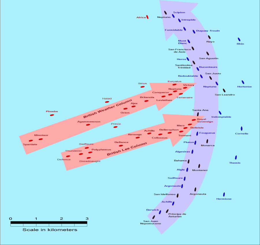
- Description: This map of the Battle of Trafalgar shows the approximate position of the two fleets at 1200 hours during the battle as the Royal Sovereign was breaking into the Franco-Spanish line. North is to the top, and Cape Trafalgar is 10 miles to the northeast.
- Size: 900 × 850 pixels.
- Source: This drawing is based on an illustration in issue number 84 of the Strategy & Tactics magazine The map was made by RJHall using the Campaign Cartographer drawing program, and the image was reduced in size 50% in Paint Shop Pro. Ship icons are not to scale.
Este archivo se encuentra bajo la licencia Creative Commons Genérica de Atribución/Compartir-Igual 2.5.
- Eres libre:
- de compartir – de copiar, distribuir y transmitir el trabajo
- de remezclar – de adaptar el trabajo
- Bajo las siguientes condiciones:
- atribución – Debes otorgar el crédito correspondiente, proporcionar un enlace a la licencia e indicar si realizaste algún cambio. Puedes hacerlo de cualquier manera razonable pero no de manera que sugiera que el licenciante te respalda a ti o al uso que hagas del trabajo.
- compartir igual – En caso de mezclar, transformar o modificar este trabajo, deberás distribuir el trabajo resultante bajo la misma licencia o una compatible como el original.
Historial del archivo
Haz clic sobre una fecha y hora para ver el archivo tal como apareció en ese momento.
| Fecha y hora | Miniatura | Dimensiones | Usuario | Comentario | |
|---|---|---|---|---|---|
| actual | 14:30 28 jul 2005 | | 900 × 850 (30 kB) | RJHall | Battle of Trafalgar situation at 1200hr, 21 October 1805. |
Usos del archivo
No hay páginas que enlacen a este archivo.
Uso global del archivo
Las wikis siguientes utilizan este archivo:
- Uso en fr.wikipedia.org
- Uso en ja.wikipedia.org