Archivo:Toconao Seen From Above.jpg
Ver la imagen en su resolución original (4000 × 2640 píxeles; tamaño de archivo: 6,07 MB; tipo MIME: image/jpeg)
Resumen
| Descripción |
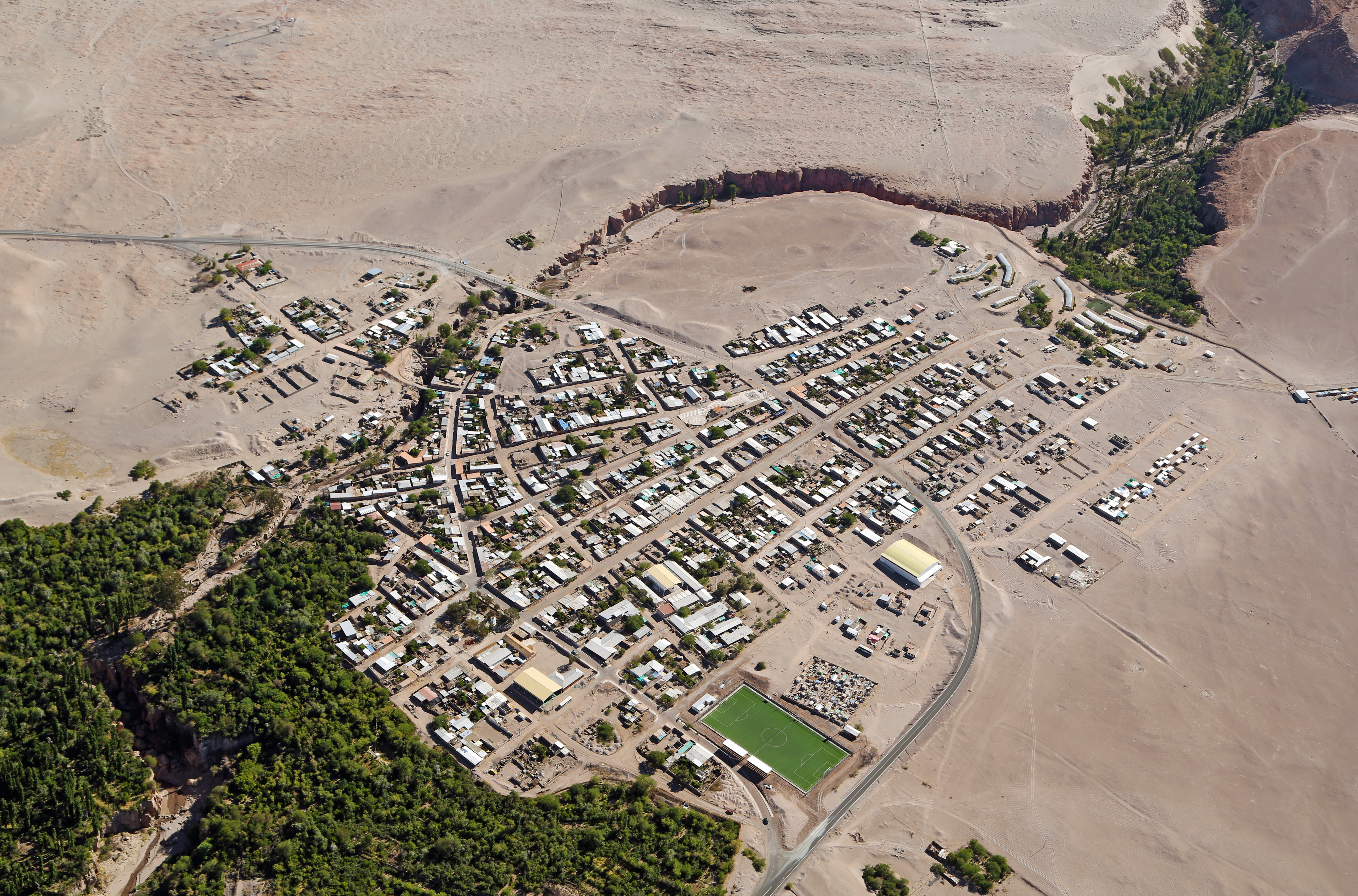
English: The small village of Toconao is the closest settlement to the largest astronomy project in existence, ALMA [1], the Atacama Large Millimeter/submillimeter Array. Toconao has less than 800 inhabitants and is located at 2475 metres above sea level in a natural oasis fed by a small mountain river on the outskirts of the driest desert in the world, the Atacama. The river doesn’t flow all year, but the local farmers have wisely built a network of dams and channels to regulate the flow of water so that they can have crops all year round.
When looking closely at this image, some buildings can be spotted, made of traditional materials such as adobe and volcanic rock, like the San Lucas Church and Bell Tower, on the bottom left of the image. In parallel with their scientific work, ALMA staff have worked with the Atacameño Elders in Toconao and other areas to recover the vision of the Universe of their culture, aiming to preserve this cultural and scientific heritage for later generations. ALMA has also been supporting an educational improvement plan at School E-21, a rural public education establishment in Toconao, since 2008. This plan, endorsed by the community, is focused on improving education in science and english. This aerial image was taken by the two crew members of the ORA Wings for Science project, Clémentine Bacri and Adrien Normier, who flew a special eco-friendly ultralight aeroplane [2] on a year-long journey around the world to help out scientists, with aerial capabilities ranging from air sampling to archaeology, biodiversity observation and 3D terrain modelling. ESO has an ongoing outreach partnership with this non-profit organisation. Short movies and amazing pictures that are produced during the flights will be used for educational purposes and for promoting local research. Their circumnavigation started in June 2012 and finished in June 2013 with a landing at the Paris Air Show. Notes [1] The Atacama Large Millimeter/submillimeter Array (ALMA), an international astronomy facility, is a partnership of Europe, North America and East Asia in cooperation with the Republic of Chile. ALMA is funded in Europe by the European Southern Observatory (ESO), in North America by the U.S. National Science Foundation (NSF) in cooperation with the National Research Council of Canada (NRC) and the National Science Council of Taiwan (NSC) and in East Asia by the National Institutes of Natural Sciences (NINS) of Japan in cooperation with the Academia Sinica (AS) in Taiwan. ALMA construction and operations are led on behalf of Europe by ESO, on behalf of North America by the National Radio Astronomy Observatory (NRAO), which is managed by Associated Universities, Inc. (AUI) and on behalf of East Asia by the National Astronomical Observatory of Japan (NAOJ). The Joint ALMA Observatory (JAO) provides the unified leadership and management of the construction, commissioning and operation of ALMA. [2] The ultralight aircraft is a NASA-award winning Pipistrel Virus SW 80 using only 7 litres of fuel per 100 kilometres — less than most cars. |
| Fecha | |
| Fuente | http://www.eso.org/public/images/potw1337a/ |
| Autor | Clem & Adri Bacri-Normier (wingsforscience.com)/ESO |
| Ubicación del objeto | | Ubicación de esta y otras imágenes en: OpenStreetMap |
|---|
Licencia
This media was created by the European Southern Observatory (ESO).
Their website states: "Unless specifically noted, the images, videos, and music distributed on the public ESO website, along with the texts of press releases, announcements, pictures of the week, blog posts and captions, are licensed under a Creative Commons Attribution 4.0 International License, and may on a non-exclusive basis be reproduced without fee provided the credit is clear and visible." To the uploader: You must provide a link (URL) to the original file and the authorship information if available. | |
Este archivo está disponible bajo la licencia Creative Commons Atribución 4.0 Internacional.
| |
| Annotations | This image is annotated: View the annotations at Commons |


.jpg)


Historial del archivo
Haz clic sobre una fecha y hora para ver el archivo tal como apareció en ese momento.
| Fecha y hora | Miniatura | Dimensiones | Usuario | Comentario | |
|---|---|---|---|---|---|
| actual | 00:57 17 sep 2013 | | 4000 × 2640 (6,07 MB) | Jmencisom | User created page with UploadWizard |
Usos del archivo
La siguiente página usa este archivo:
Uso global del archivo
Las wikis siguientes utilizan este archivo:
- Uso en en.wikipedia.org
- Uso en fa.wikipedia.org
- Uso en gl.wikipedia.org
- Uso en www.wikidata.org