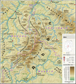
Archivo:Teutoburger Wald - Deutsche Mittelgebirge, Serie A-de.png

Tamaño de esta previsualización: 795 × 599 píxeles. Otras resoluciones: 319 × 240 píxeles · 637 × 480 píxeles · 1019 × 768 píxeles · 1280 × 965 píxeles · 2560 × 1930 píxeles · 3250 × 2450 píxeles.
Ver la imagen en su resolución original (3250 × 2450 píxeles; tamaño de archivo: 12,42 MB; tipo MIME: image/png)
Historial del archivo
Haz clic sobre una fecha y hora para ver el archivo tal como apareció en ese momento.
| Fecha y hora | Miniatura | Dimensiones | Usuario | Comentario | |
|---|---|---|---|---|---|
| actual | 09:16 6 abr 2023 |  | 3250 × 2450 (12,42 MB) | Thoroe | == {{int:filedesc}} == {{Information |description ={{en|1=Topographic map of the Teutoburg Forest with Weser Uplands}} {{de|1=Topografische Karte des Teutoburger Waldes mit Weserbergland}} |date =2023-04-06 |source ={{Own using}} *[http://gmt.soest.hawaii.edu Generic Mapping Tools (GMT)] with [http://dds.cr.usgs.gov/srtm/version2_1/SRTM3/ SRTM3 V2.1 data] *[http://www.openstreetmap.... |
Usos del archivo
La siguiente página usa este archivo:
Uso global del archivo
Las wikis siguientes utilizan este archivo:
- Uso en de.wikipedia.org
- Teutoburger Wald
- Solling
- Süntel
- Eggegebirge
- Bramwald
- Reinhardswald
- Oberes Wesertal
- Mettingen
- Lipper Bergland
- Großer Weserbogen
- Exten
- Osnabrücker Hügelland
- Benutzer:Thoroe
- Liste von Bergen und Erhebungen im Teutoburger Wald
- Benutzer:Thoroe/Making of Thüringer Wald
- Wikipedia:Kartenwerkstatt/Archiv/2023-04
- Fossillagerstätte Lengerich
- Uso en de.wikivoyage.org
- Uso en en.wikipedia.org
- Uso en frr.wikipedia.org
- Uso en nl.wikipedia.org


