Archivo:SolarGIS-Solar-map-Latin-America-en.png

Ver la imagen en su resolución original (730 × 900 píxeles; tamaño de archivo: 434 kB; tipo MIME: image/png)
Resumen
| Descripción |
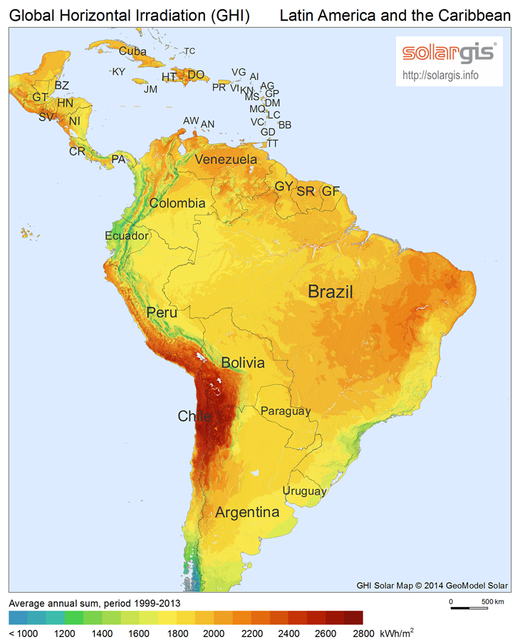
English: Solar Radiation Map: Global Horizontal Irradiation Map of Latin America, SolarGIS. |
| Fecha | |
| Fuente | |
| Autor | SolarGIS © 2014 GeoModel Solar |
| Permiso (Reutilización de este archivo) |
The maps are free for public use, their reproduction and adaptation is authorised provided the following source is acknowledged: SolarGIS © 2014 GeoModel Solar By downloading a free map, you acknowledge that GeoModel Solar retains all rights, titles, and interest in the information provided by the maps, including the copyright, SolarGIS logo and all other intellectual property rights, and that GeoModel Solar has the right to make these maps available under Creative Commons Attribution-ShareAlike 3.0 Unported License. GeoModel Solar makes no representations or warranties about the accuracy, reliability, completeness or suitability for any particular purpose of the free maps. You agree that GeoModel Solar is under no liability for any loss or damage (including consequential damage) that you may suffer from the use of the free maps. |
Licencia
- Eres libre:
- de compartir – de copiar, distribuir y transmitir el trabajo
- de remezclar – de adaptar el trabajo
- Bajo las siguientes condiciones:
- atribución – Debes otorgar el crédito correspondiente, proporcionar un enlace a la licencia e indicar si realizaste algún cambio. Puedes hacerlo de cualquier manera razonable pero no de manera que sugiera que el licenciante te respalda a ti o al uso que hagas del trabajo.
- compartir igual – En caso de mezclar, transformar o modificar este trabajo, deberás distribuir el trabajo resultante bajo la misma licencia o una compatible como el original.
Historial del archivo
Haz clic sobre una fecha y hora para ver el archivo tal como apareció en ese momento.
| Fecha y hora | Miniatura | Dimensiones | Usuario | Comentario | |
|---|---|---|---|---|---|
| actual | 18:05 13 nov 2014 | | 730 × 900 (434 kB) | Rfassbind | {{Information |Description={{en|1=Solar Radiation Map: Global Horizontal Irradiation Map of Latin America, SolarGIS.}} |Source= *[http://solargis.info/doc/_pics/freemaps/1000px/ghi/SolarGIS-Solar-map-Latin-America-en.png image] *[http://solargis.info/d... |
Usos del archivo
La siguiente página usa este archivo:
Uso global del archivo
Las wikis siguientes utilizan este archivo:
- Uso en ar.wikipedia.org
- Uso en azb.wikipedia.org
- Uso en az.wikipedia.org
- Uso en cs.wikipedia.org
- Uso en en.wikipedia.org
- Uso en eu.wikipedia.org
- Uso en fa.wikipedia.org
- Uso en ko.wikipedia.org
- Uso en uk.wikipedia.org
- Географія Суринаму
- Географія Тринідаду і Тобаго
- Географія Болівії
- Географія Венесуели
- Географія Колумбії
- Географія Уругваю
- Географія Парагваю
- Географія Гаяни
- Фолклендські острови
- Географія Монтсеррату
- Географія Кюрасао
- Географія Аруби
- Географія Островів Теркс і Кайкос
- Географія Сен-Бартельмі
- Географія Еквадору
- Географія Ангільї
- Географія Антигуа і Барбуди
- Географія Барбадосу
- Географія Британських Віргінських Островів
- Географія Кайманових Островів
- Географія Домініки
- Географія Гренади
- Географія Сент-Кіттс і Невісу
- Географія Сент-Люсії
- Географія Американських Віргінських Островів
- Uso en uz.wikipedia.org