Archivo:Silver City Highway location map.svg

Ver la imagen en su resolución original ((Imagen SVG, nominalmente 417 × 989 pixels, tamaño de archivo: 203 kB))
Resumen
| Descripción |
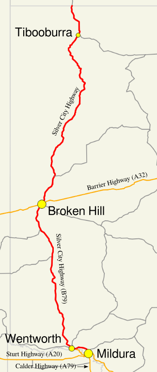
English: Map of the Silver City Highway |
| Fecha | |
| Fuente | Own work, Created in Quantum GIS and Inkscape - Sources: Geoscience Australia Data, then overlaid with town and highway/route names. |
| Autor |
Original author of GIS data: © Commonwealth of Australia (Geoscience Australia) 2013. |
| Permiso (Reutilización de este archivo) |
Original author of GIS data: "Save for the content on this website supplied by third parties, the Geoscience Australia logo, the Commonwealth Coat of Arms, and any material protected by a trade mark, Geoscience Australia has applied the Creative Commons Attribution 3.0 Australia licence. Geoscience Australia asserts the right to be recognised as author of the original material in the following manner: |
Licencia
GIS data
Geoscience Australia asserts the right to be recognised as author of the original material as displayed above - Please ensure any derivatives also recognise as author of the original material
- Eres libre:
- de compartir – de copiar, distribuir y transmitir el trabajo
- de remezclar – de adaptar el trabajo
- Bajo las siguientes condiciones:
- atribución – Debes otorgar el crédito correspondiente, proporcionar un enlace a la licencia e indicar si realizaste algún cambio. Puedes hacerlo de cualquier manera razonable pero no de manera que sugiera que el licenciante te respalda a ti o al uso que hagas del trabajo.


|
Hace falta corroborar las categorías de esta imagen. ¡Inténtalo ahora!
|
Historial del archivo
Haz clic sobre una fecha y hora para ver el archivo tal como apareció en ese momento.
| Fecha y hora | Miniatura | Dimensiones | Usuario | Comentario | |
|---|---|---|---|---|---|
| actual | 03:43 26 oct 2013 | | 417 × 989 (203 kB) | Nbound | {{Information |description={{en|1=Map of the Silver City Highway}} |date=2013-10-26 |source= Own work, Created in Quantum GIS and Inkscape - Sources: Geoscience Australia Data, then overlaid with town and highway/route ... |
Usos del archivo
La siguiente página usa este archivo:
Uso global del archivo
Las wikis siguientes utilizan este archivo:
- Uso en en.wikipedia.org
- Uso en www.wikidata.org