Archivo:Rockford-Freeport-Rochelle CSA.png
No se dispone de una resolución más alta.
Rockford-Freeport-Rochelle_CSA.png (298 × 494 píxeles; tamaño de archivo: 20 kB; tipo MIME: image/png)
| Descripción |
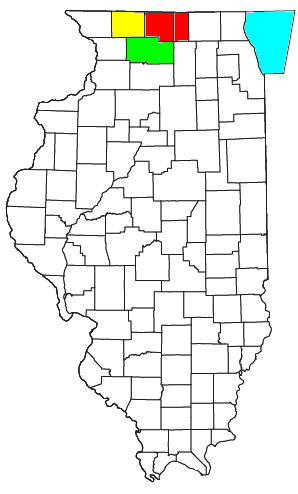
Locator map of the Rockford-Freeport-Rochelle Combined Statistical Area in the central part of the U.S. state of Illinois. The three components of the CSA are colored separately: |
||
| Fecha | |||
| Fuente |
Modified from this United States Census Bureau file, based on the following Census definitions lists: |
||
| Autor | User:Nyttend | ||
| Permiso (Reutilización de este archivo) |
US Government work is public domain, and my work is
|
Historial del archivo
Haz clic sobre una fecha y hora para ver el archivo tal como apareció en ese momento.
| Fecha y hora | Miniatura | Dimensiones | Usuario | Comentario | |
|---|---|---|---|---|---|
| actual | 15:05 30 jul 2008 | | 298 × 494 (20 kB) | Nyttend | {{Information |Description=Locator map of the {{w|Rockford metropolitan area|Rockford-Freeport-Rochelle}} {{w|Combined Statistical Area}} in the central part of the {{w|U.S. state}} of {{w|Illinois}}. The three components of the CSA are colored separatel |
Usos del archivo
La siguiente página usa este archivo:
Uso global del archivo
Las wikis siguientes utilizan este archivo:
- Uso en de.wikipedia.org
- Uso en tr.wikipedia.org