Archivo:Panulirus interruptus distribution.png
No se dispone de una resolución más alta.
Panulirus_interruptus_distribution.png (711 × 527 píxeles; tamaño de archivo: 67 kB; tipo MIME: image/png)
| Descripción |
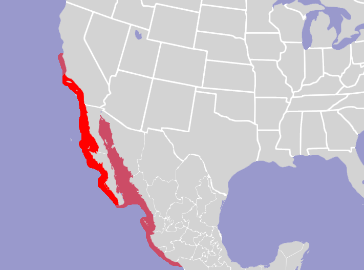
English: Map of North America and its second-level political divisions. Canadian provinces, US and Mexican states. Canada, Mexico, United States. Non-contiguous parts of a states/provinces are "grouped" together with the main area of the state/provinces, so any state/provinces can be coloured in completion with one click anywhere on the state/provinces's area. Also, all states/provinces have a "id" attached to them, making them easy to find. Select "find" and then enter in the state/provinces's ISO 3166-2 code in the "id" field to find it. The codes can be found here (Canada), here (USA) and here (Mexico). |
| Fecha | (UTC) |
| Fuente | |
| Autor |
|
| Esta es una imagen retocada, lo que significa que ha sido alterada digitalmente de su versión original. Modificaciones: Added distribution of Panulirus interruptus'. La original se puede ver aquí: North America second level political division 2.svg. Las modificaciones las hizo Stemonitis.
|
Yo, el titular de los derechos de autor de esta obra, la publico en los términos de la siguiente licencia:
Este archivo se encuentra bajo la licencia Creative Commons Genérica de Atribución/Compartir-Igual 2.5.
- Eres libre:
- de compartir – de copiar, distribuir y transmitir el trabajo
- de remezclar – de adaptar el trabajo
- Bajo las siguientes condiciones:
- atribución – Debes otorgar el crédito correspondiente, proporcionar un enlace a la licencia e indicar si realizaste algún cambio. Puedes hacerlo de cualquier manera razonable pero no de manera que sugiera que el licenciante te respalda a ti o al uso que hagas del trabajo.
- compartir igual – En caso de mezclar, transformar o modificar este trabajo, deberás distribuir el trabajo resultante bajo la misma licencia o una compatible como el original.
Registro original de carga
This image is a derivative work of the following images:
- File:North_America_second_level_political_division_2.svg licensed with Cc-by-sa-2.5
- 2007-12-08T23:23:36Z Lokal Profil 1712x1992 (335351 Bytes) Code cleanup
- 2007-10-07T07:55:13Z AlexCovarrubias 1712x1992 (350437 Bytes) == Summary == {{Information |Description=Map of North America and its second-level political divisions. Canadian provinces, US and Mexican states. Canada, Mexico, United States. |Source=Canada and US map by Alan Rockefeller.
Uploaded with derivativeFX
Historial del archivo
Haz clic sobre una fecha y hora para ver el archivo tal como apareció en ese momento.
| Fecha y hora | Miniatura | Dimensiones | Usuario | Comentario | |
|---|---|---|---|---|---|
| actual | 18:36 12 abr 2010 | | 711 × 527 (67 kB) | Stemonitis | {{Information |Description={{en|Map of North America and its second-level political divisions. Canadian provinces, US and Mexican states. Canada, Mexico, United States. Non-contiguous parts of a states/provinces are "grouped" together with the main area |
Usos del archivo
La siguiente página usa este archivo:
Uso global del archivo
Las wikis siguientes utilizan este archivo:
- Uso en ceb.wikipedia.org
- Uso en en.wikipedia.org
- Uso en la.wikipedia.org
- Uso en sd.wikipedia.org
- Uso en sv.wikipedia.org
- Uso en vi.wikipedia.org
- Uso en www.wikidata.org
- Uso en zh.wikipedia.org