Archivo:PIA24021-Ceres-OccatorCrater-Animated-20200810.gif

Ver la imagen en su resolución original (1280 × 720 píxeles; tamaño de archivo: 17,76 MB; tipo MIME: image/gif, bucleado, 30 frames, 6,0s)
Resumen
| Descripción |
English: Highlighting Bright Areas of Ceres' Occator Crater[1]
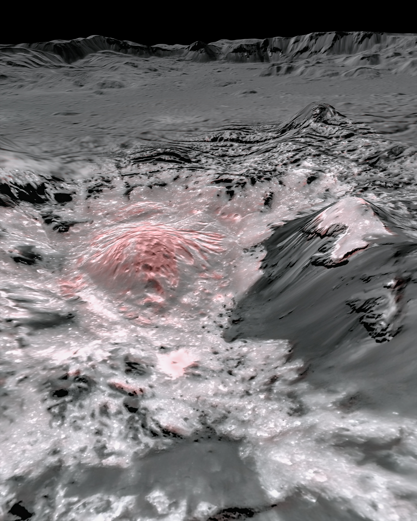
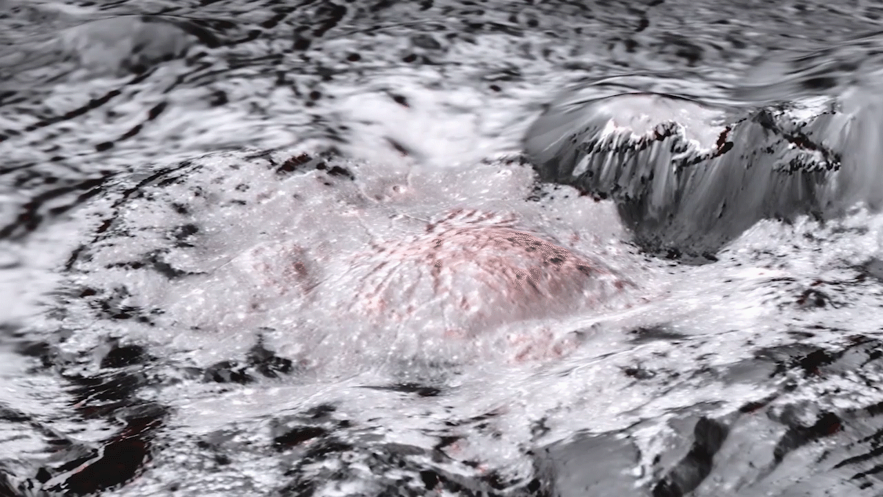
NASAs Dawn spacecraft captured pictures, which were combined to create this false-color view of a region in Occator Crater on the dwarf planet Ceres. click here for larger version of figure 1 for PIA24021 click here for animated gif of figure 2 for PIA24021 NASA's Dawn spacecraft captured pictures in visible and infrared wavelengths, which were combined to create this false-color view of a region in 57-mile-wide (92-kilometer-wide) Occator Crater on the dwarf planet Ceres (in the main asteroid belt between Mars and Jupiter). Here, recently exposed brine, or salty liquids, in the center of the crater were pushed up from a deep reservoir below Ceres' crust. In this view, they appear reddish. In the foreground, is Cerealia Facula ("facula" means bright area), a 9-mile-wide (15-kilometer-wide) region with a composition dominated by salts. The central dome, Cerealia Tholus, is about 1.9 miles (3 kilometers) across at its base and 1,100 feet (340 meters) tall. The dome is inside a central depression about 3,000 feet (900 meters) deep. The area depicted in this scene is about 1.3 miles (2.1 kilometers) wide in the foreground, about 7 miles (11 kilometers) wide across the dome, and 35 miles (56 kilometers) wide in the background, where the crater rim rises against the black sky. The distance from the near point (at the bottom) to the far point (at the top) is about 32 miles (52 kilometers). This mosaic is made from multiple images Dawn captured during its second extended mission in 2018 from an altitude of about 22 miles (35 kilometers). Those were combined with a topographic map based on images obtained during Dawn's prime mission and first extended mission in 2016, from an altitude of about 240 miles (385 kilometers). The resolution varies from about 11 feet (3.5 meters) per pixel in the bright regions to about 115 feet (35 meters) per pixel in the background. The color data that is overlain on the topographic data was obtained during the prime mission in 2015 when the spacecraft was at an altitude of 915 miles (1470 kilometers). It has a resolution of 450 feet (140 meters) per pixel. Figure 1 is a close-up view; the scene is about 1.9 miles (3 kilometers) wide in the foreground and 22 miles (35 kilometers) wide in the background, from rim to rim. The distance from the near point (at the bottom) to the far point (at the top) is about 27 miles (44 kilometers). Both images were produced by Nico Schmedemann, Guni Thangjam and Andreas Nathues from the Dawn Framing Camera Team. Figure 2 links to an animated gif, made from the Occator Crater mosaics. Video used to create this animated gif was made by Nico Schmedemann, Guni Thangjam and Andreas Nathues from the Dawn Framing Camera Team. Dawn's mission is managed by NASA's Jet Propulsion Laboratory, a division of Caltech, for the agency's Science Mission Directorate in Washington. Dawn is a project of the directorate's Discovery Program, managed by NASA's Marshall Space Flight Center in Huntsville, Alabama. JPL is responsible for overall Dawn mission science. Northrop Grumman in Dulles, Virginia, designed and built the spacecraft. The German Aerospace Center, Max Planck Institute for Solar System Research, Italian Space Agency and Italian National Astrophysical Institute are international partners on the mission team. For a complete list of mission participants, visit: https://solarsystem.nasa.gov/missions/dawn/overview/. References
|
| Fecha | |
| Fuente | https://photojournal.jpl.nasa.gov/archive/PIA24021.gif |
| Autor | NASA/JPL-Caltech/UCLA/MPS/DLR/IDA |
Licencia
| Este archivo es de dominio público porque fue creado por la NASA. Las políticas sobre copyright de la NASA estipulan que «el material de la NASA no está protegido con copyright a menos que se indique lo contrario». (Políticas sobre copyright de la NASA o Políticas sobre la utilización de imágenes del Jet Propulsion Laboratory). | ||
 |
Advertencias:
|
Historial del archivo
Haz clic sobre una fecha y hora para ver el archivo tal como apareció en ese momento.
| Fecha y hora | Miniatura | Dimensiones | Usuario | Comentario | |
|---|---|---|---|---|---|
| actual | 03:05 11 ago 2020 | | 1280 × 720 (17,76 MB) | Drbogdan | Uploaded a work by NASA/JPL-Caltech/UCLA/MPS/DLR/IDA from https://photojournal.jpl.nasa.gov/archive/PIA24021.gif with UploadWizard |
Usos del archivo
La siguiente página usa este archivo: