Archivo:Mdwild31c.JPG

Tamaño de esta previsualización: 391 × 600 píxeles. Otras resoluciones: 156 × 240 píxeles · 313 × 480 píxeles · 705 × 1081 píxeles.
Ver la imagen en su resolución original (705 × 1081 píxeles; tamaño de archivo: 161 kB; tipo MIME: image/jpeg)
Resumen
| Descripción |
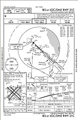
English: ILS or LOC/DME RWY 31C approach chart. Prepared by the National Aeronautical Charting Office for the Federal Aviation Administration. Minimums listed in lower right indicate with an operating Instrument Landing System a pilot can safely descend to 863' above sea level or 250' above ground level with a runway visual range of 4,000'. No longer valid for navigation. |
| Fuente | |
| Autor | Skywayman at en.wikipedia |
Licencia
This image or file is a work of a Federal Aviation Administration employee, taken or made as part of that person's official duties. As a work of the U.S. federal government, the image is in the public domain in the United States.
|
 |
Registro original de carga
Aquí se muestra la página de descripción original. Los siguientes nombres de usuario se refieren a en.wikipedia.
Upload date | User | Bytes | Dimensions | Comment
- 2005-12-16 04:07 (UTC) | Skywayman | 164486 (bytes) | 705×1081 | ILS or LOC/DME RWY 31C approach chart. Prepared by the National Aeronautical Charting Office for the Federal Aviation Administration
Historial del archivo
Haz clic sobre una fecha y hora para ver el archivo tal como apareció en ese momento.
| Fecha y hora | Miniatura | Dimensiones | Usuario | Comentario | |
|---|---|---|---|---|---|
| actual | 07:03 18 sep 2011 | | 705 × 1081 (161 kB) | SreeBot | (Original text) : ILS or LOC/DME RWY 31C approach chart. Prepared by the National Aeronautical Charting Office for the Federal Aviation Administration |
Usos del archivo
La siguiente página usa este archivo:
Uso global del archivo
Las wikis siguientes utilizan este archivo:
- Uso en en.wikipedia.org
- Uso en he.wikipedia.org
- Uso en it.wikipedia.org
- Uso en ja.wikipedia.org
- Uso en pl.wikipedia.org
- Uso en pt.wikipedia.org