Archivo:Map of Cumberland County Pennsylvania With Municipal and Township Labels.png
No se dispone de una resolución más alta.
Map_of_Cumberland_County_Pennsylvania_With_Municipal_and_Township_Labels.png (742 × 395 píxeles; tamaño de archivo: 52 kB; tipo MIME: image/png)
Resumen
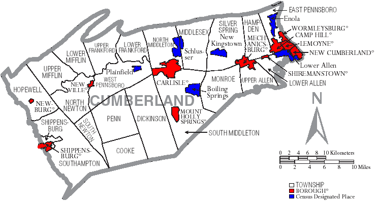
Map of Cumberland County, Pennsylvania, United States with township and municipal boundaries is taken from US Census website [1] and modified by User:Ruhrfisch in April 2006. My modifications licensed under the GNU Free Documentation License.
Source: US Census website [2]
Licencia

|
Se autoriza la copia, distribución y modificación de este documento bajo los términos de la licencia de documentación libre GNU, versión 1.2 o cualquier otra que posteriormente publique la Fundación para el Software Libre; sin secciones invariables, textos de portada, ni textos de contraportada. Se incluye una copia de la dicha licencia en la sección titulada Licencia de Documentación Libre GNU. |
| Este archivo se encuentra bajo la licencia Creative Commons Genérica de Atribución/Compartir-Igual 3.0. | ||
| ||
| Esta etiqueta de licencia fue agregada a este archivo como parte de la actualización de la licencia GFDL. |
Historial del archivo
Haz clic sobre una fecha y hora para ver el archivo tal como apareció en ese momento.
| Fecha y hora | Miniatura | Dimensiones | Usuario | Comentario | |
|---|---|---|---|---|---|
| actual | 15:28 13 sep 2008 | | 742 × 395 (52 kB) | Ruhrfisch | Cleanup, all other information the same |
| 21:11 11 abr 2006 |  | 742 × 395 (53 kB) | Ruhrfisch | Map of Cumberland County, Pennsylvania, United States with township and municipal boundaries is taken from US Census website [http://www2.census.gov/geo/maps/general_ref/cousub_outline/cen2k_pgsz/pa_cosub.pdf] and modified by User:Ruhrfisch in April 2 |
Usos del archivo
La siguiente página usa este archivo:
Uso global del archivo
Las wikis siguientes utilizan este archivo:
- Uso en de.wikipedia.org
- Uso en en.wikipedia.org
- Uso en it.wikipedia.org
- Uso en ja.wikipedia.org
- Uso en kw.wikipedia.org
- Uso en nl.wikipedia.org
- Uso en pl.wikipedia.org
- Uso en pt.wikipedia.org