Archivo:Map of Blair County Pennsylvania With Municipal and Township Labels.png
No se dispone de una resolución más alta.
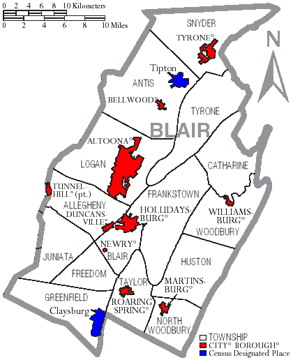
Map_of_Blair_County_Pennsylvania_With_Municipal_and_Township_Labels.png (420 × 516 píxeles; tamaño de archivo: 36 kB; tipo MIME: image/png)
Resumen
| Descripción | Map of Blair County, Pennsylvania, United States with township and municipal boundaries |
| Fecha | |
| Fuente | taken from US Census website [1] and modified by User:Ruhrfisch |
| Autor | US Census, Ruhrfisch |
| Permiso (Reutilización de este archivo) |
US Census / US Government work is public domain, my modifications licensed under the GNU Free Documentation License |
| Otras versiones | one with error (had Tunnelhill) |
Licencia
I, Ruhrfisch, titular de los derechos de autor de esta obra, la publica en los términos de las siguientes licencias:

|
Se autoriza la copia, distribución y modificación de este documento bajo los términos de la licencia de documentación libre GNU, versión 1.2 o cualquier otra que posteriormente publique la Fundación para el Software Libre; sin secciones invariables, textos de portada, ni textos de contraportada. Se incluye una copia de la dicha licencia en la sección titulada Licencia de Documentación Libre GNU. |
| Este archivo se encuentra bajo la licencia Creative Commons Genérica de Atribución/Compartir-Igual 3.0. | ||
| Atribución: I, Ruhrfisch | ||
| ||
| Esta etiqueta de licencia fue agregada a este archivo como parte de la actualización de la licencia GFDL. |
Este archivo se encuentra bajo la licencia Creative Commons Genérica de Atribución/Compartir-Igual 2.5.
Atribución: I, Ruhrfisch
- Eres libre:
- de compartir – de copiar, distribuir y transmitir el trabajo
- de remezclar – de adaptar el trabajo
- Bajo las siguientes condiciones:
- atribución – Debes otorgar el crédito correspondiente, proporcionar un enlace a la licencia e indicar si realizaste algún cambio. Puedes hacerlo de cualquier manera razonable pero no de manera que sugiera que el licenciante te respalda a ti o al uso que hagas del trabajo.
- compartir igual – En caso de mezclar, transformar o modificar este trabajo, deberás distribuir el trabajo resultante bajo la misma licencia o una compatible como el original.
Puedes usar la licencia que prefieras.
and
Esta imagen o archivo es un trabajo de un Oficina del Censo de los Estados Unidos empleado, tomado o hecho como parte de las funciones oficiales de esa persona. Como a trabajo of the Gobierno federal de los EE.UU., la imagen está en el dominio público.
|
 |
NOTA: ¡Por favor, no utilices directamente esta plantilla! Es solamente una traducción.
Historial del archivo
Haz clic sobre una fecha y hora para ver el archivo tal como apareció en ese momento.
| Fecha y hora | Miniatura | Dimensiones | Usuario | Comentario | |
|---|---|---|---|---|---|
| actual | 14:51 13 sep 2008 | | 420 × 516 (36 kB) | Ruhrfisch | Cleanup, all other information the same |
| 13:39 19 may 2007 |  | 420 × 516 (36 kB) | Ruhrfisch | == Summary == {{Information| |Description= Map of Blair County, Pennsylvania, United States with township and municipal boundaries |Source= taken from US Census website [http://www2.census.gov/geo/maps/general_ref/cousub_outline/cen2k_pgsz/pa_cosub.pdf] | |
| 21:00 18 may 2007 |  | 420 × 516 (36 kB) | Ruhrfisch | {{Information |Description=Map of Blair County Pennsylvania With Municipal and Township Labels.png |Source= taken from US Census website [http://www2.census.gov/geo/maps/general_ref/cousub_outline/cen2k_pgsz/pa_cosub.pdf] and modified by [[User:Ruhrfisch] | |
| 13:26 8 abr 2006 |  | 420 × 516 (38 kB) | Ruhrfisch | Map of Blair County, Pennsylvania, United States with township and municipal boundaries is taken from US Census website [http://www2.census.gov/geo/maps/general_ref/cousub_outline/cen2k_pgsz/pa_cosub.pdf] and modified by User:Ruhrfisch in April 2006. |
Usos del archivo
La siguiente página usa este archivo:
Uso global del archivo
Las wikis siguientes utilizan este archivo:
- Uso en de.wikipedia.org
- Uso en en.wikipedia.org
- Uso en ja.wikipedia.org
- Uso en nl.wikipedia.org
- Uso en pl.wikipedia.org