Archivo:Landsat7 dry valley lrg.jpg

Ver la imagen en su resolución original (6245 × 3640 píxeles; tamaño de archivo: 2,96 MB; tipo MIME: image/jpeg)
Resumen
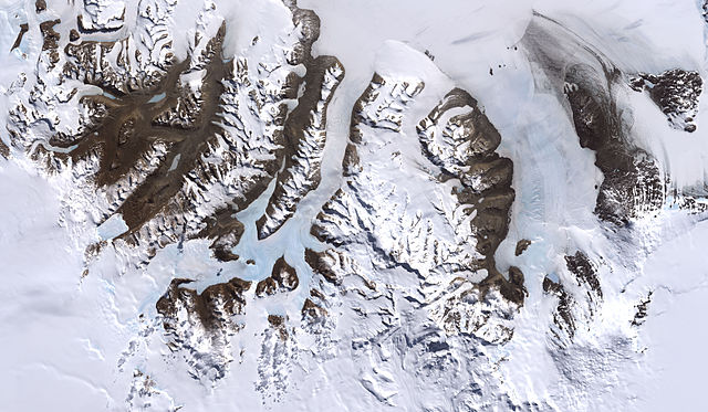
McMurdo Dry Valleys, Antarctica
From: http://visibleearth.nasa.gov/view_rec.php?id=2414
Credit: Image by Robert Simmon, based on data provided by the NASA GSFC Oceans and Ice Branch and the Landsat 7 Science Team
One of the few areas of Antarctica not covered by thousands of meters of ice, the McMurdo Dry Valleys stand out in this satellite image. For a few weeks each summer temperatures are warm enough to melt glacial ice, creating streams that feed freshwater lakes that lie at the bottom of the valleys. Beneath a cap of ice these lakes remains unfrozen year-round, supporting colonies of bacteria and phytoplankton. Over the past 14 years, however, summers have been colder than usual, and the lakes are becoming more and more frozen. If the trend continues, the biological communities they support may go into hibernation.
Most of Antarctica has cooled along with the Dry Valleys, in contrast to much of the rest of the Earth, which has warmed over the past 100 years. No one knows if the trend is related to global climate, or just a quirk in the weather.
This image was acquired by Landsat 7’s Enhanced Thematic Mapper plus (ETM+) instrument on December 18, 1999.
Licencia
| Este archivo es de dominio público porque fue creado por la NASA. Las políticas sobre copyright de la NASA estipulan que «el material de la NASA no está protegido con copyright a menos que se indique lo contrario». (Políticas sobre copyright de la NASA o Políticas sobre la utilización de imágenes del Jet Propulsion Laboratory). | ||
 |
Advertencias:
|
| Annotations | This image is annotated: View the annotations at Commons |
Historial del archivo
Haz clic sobre una fecha y hora para ver el archivo tal como apareció en ese momento.
| Fecha y hora | Miniatura | Dimensiones | Usuario | Comentario | |
|---|---|---|---|---|---|
| actual | 20:45 4 jul 2007 | | 6245 × 3640 (2,96 MB) | Xhienne | Losslessly removed progressive marker so that a thumbnail can be generated |
| 00:51 2 ene 2006 |  | 6245 × 3640 (2,91 MB) | Aude | McMurdo Dry Valleys, Antarctica ''From: [http://visibleearth.nasa.gov/view_rec.php?id=2414 http://visibleearth.nasa.gov/view_rec.php?id=2414] Credit: Image by Robert Simmon, based on data provided by the NASA GSFC Oceans and Ice Branch and the Landsat 7 |
Usos del archivo
La siguiente página usa este archivo:
Uso global del archivo
Las wikis siguientes utilizan este archivo:
- Uso en ar.wikipedia.org
- Uso en az.wikipedia.org
- Uso en ca.wikipedia.org
- Uso en de.wikipedia.org
- Uso en en.wikipedia.org
- Uso en en.wikiversity.org
- Uso en fa.wikipedia.org
- Uso en fi.wikipedia.org
- Uso en fr.wikipedia.org
- Uso en nl.wikipedia.org
- Uso en nn.wikipedia.org
- Uso en no.wikipedia.org
- Uso en pl.wikipedia.org
- Uso en pt.wikipedia.org
- Uso en th.wikipedia.org
- Uso en tr.wikipedia.org
- Uso en uk.wikipedia.org