Archivo:Lacey V. Murrow Bridge construction.jpg

Lacey_V._Murrow_Bridge_construction.jpg(600 × 473 píxeles; tamaño de archivo: 266 kB; tipo MIME: image/jpeg)

Esto es una imagen de un lugar o edificio incluido en el Registro Nacional de Lugares Históricos de los Estados Unidos. Su número de referencia es 87000866.

Resumen

Descripción
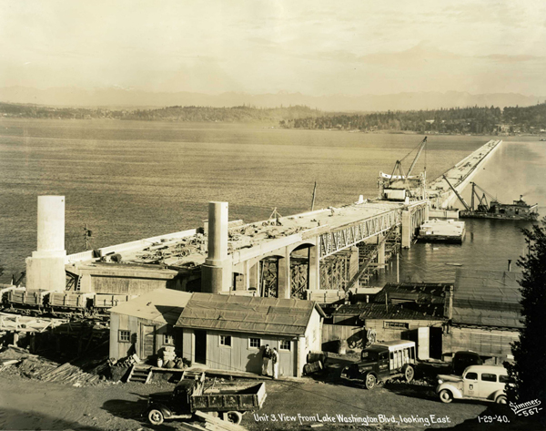
English: Many of the people traveling across one of Lake Washington’s floating bridges likely take the innovative spans for granted, but when the lake’s very first floating bridge opened to traffic on July 2, 1940, it was the culminating moment of a remarkable engineering feat.

Known as the Lacey V. Murrow Bridge, it was the largest and longest floating bridge ever built at that time, and it was the first to be built with reinforced concrete. (It was also known by many as the first I-90 floating bridge.) When it opened, the bridge represented one of “engineering’s greatest triumphs,” in the same category as Boulder Dam and the Golden Gate Bridge.

Construction began on the Murrow Bridge on January 1, 1939. This photo, from the Washington State Department of Transportation Photograph Collection, was taken on January 29, 1940, nearly 71 years ago to the day.

It was rebuilt after part of the bridge sank on November 25, 1990, with the refurbished bridge opening on September 12, 1993. Construction on a second I-90 floating bridge began in April 1986 and was open to traffic on June 4, 1989. That span is known as the Homer Hadley Bridge.
Fecha
Fuente http://blogs.sos.wa.gov/FromOurCorner/index.php/2011/01/building-the-first-lake-washington-floating-bridge/
Autor Washngton State Archives
Posición de la cámara47° 35′ 22,56″ N, 122° 17′ 21,12″ O Kartographer map based on OpenStreetMap.Ubicación de esta y otras imágenes en: OpenStreetMapinfo
La información geográfica de este archivo fue estimada retrospectivamente.
Por lo tanto, la ubicación puede ser algo imprecisa.
Se recomienda encarecidamente verificar y perfeccionar estas coordenadas.

Licencia

Public domain Este trabajo ha sido liberado al dominio público por su autor, The State of Washington. Esto aplica para todo el mundo.
En algunos países esto puede no ser legalmente factible; si ello ocurriese:
The State of Washington otorga a cualquier persona el derecho de usar este trabajo para cualquier propósito, sin ningún tipo de condición, a menos que éstas sean requeridas por la ley.

Leyendas

Añade una explicación corta acerca de lo que representa este archivo

Elementos representados en este archivo

representa a

47°35'22.6"N, 122°17'21.1"W

Historial del archivo

Haz clic sobre una fecha y hora para ver el archivo tal como apareció en ese momento.

Fecha y horaMiniaturaDimensionesUsuarioComentario
actual20:10 12 mar 2011Miniatura de la versión del 20:10 12 mar 2011600 × 473 (266 kB)SchmuckyTheCat~commonswiki{{Information |Description ={{en|1=Many of the people traveling across one of Lake Washington’s floating bridges likely take the innovative spans for granted, but when the lake’s very first floating bridge opened to traffic on July 2, 1940, it was

La siguiente página usa este archivo:

Uso global del archivo

Metadatos