Archivo:IAN 0936 Genesio 1538 Preveza.jpg

Tamaño de esta previsualización: 800 × 544 píxeles. Otras resoluciones: 320 × 217 píxeles · 640 × 435 píxeles · 1024 × 696 píxeles · 1280 × 870 píxeles · 2560 × 1739 píxeles · 3485 × 2368 píxeles.
Ver la imagen en su resolución original (3485 × 2368 píxeles; tamaño de archivo: 3,48 MB; tipo MIME: image/jpeg)
Resumen
| Título |
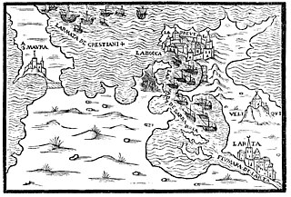
Italiano: Il lvocho dove se ritrvova le armate de Christiani, et del Tvrcho. English: The place where the Christian and the Turkish Fleets met. Ελληνικά: Ο χώρος που συναντήθηκαν οι στόλοι των Χριστιανών και των Τούρκων. |
|||||||||||||||||||||||
| Descripción |
English: A plan of the place where the fleets of the Christians and the Turks met for the battle of Preveza, in September 1538. Woodcut from a printed notice by Francesco Genesio of Corfu. Nikos D. Karabelas reproduction map collection, Actia Nicopolis Foundation, Preveza, Greece. Ελληνικά: Απεικόνιση των στόλων των Χριστιανών και των Τούρκων πριν τη ναυμαχία της Πρέβεζας, Σεπτέμβριος 1538. Ξυλογραφία από πληροφοριακό έντυπο του Francesco Genesio του 1538. Συλλογή αναπαραγωγών παλαιών χαρτών Νίκου Δ. Καράμπελα, Ίδρυμα Ακτία Νικόπολις, Πρέβεζα |
|||||||||||||||||||||||
| Fecha | ||||||||||||||||||||||||
| Fuente | Avisi particolari da Corfu, delle Armate de Christiani, et del Turcho. Con il disegno del Golfo dove Barbarossa e con l’ Armata Turchesca, written on 20th September 1538 in Corfu, and published most probably in Venice in the same year. See, Nikos D. Karabelas, The Ottoman conquest of Preveza and its first castle, figure 6, p. 992. | |||||||||||||||||||||||
| Creador |
Francesco Genesio |
|||||||||||||||||||||||
| Permiso (Reutilización de este archivo) |
Este archivo está disponible bajo la licencia Creative Commons Atribución 4.0 Internacional.
|
|||||||||||||||||||||||
| Geotemporal data | ||||||||||||||||||||||||
| Fecha representada | September 1538, during the sea battle of Preveza. | |||||||||||||||||||||||
| Map location | Preveza, Greece | |||||||||||||||||||||||
| Map type | map/plan | |||||||||||||||||||||||
| Heading |
 |
|||||||||||||||||||||||
| Bounding box |
|
|||||||||||||||||||||||
| Georeferencing | If inappropriate please set warp_status = skip to hide. | |||||||||||||||||||||||
| Bibliographic data | ||||||||||||||||||||||||
| Serie |
English: Actia Nicopolis Foundation, Preveza, Greece. Nikos D. Karabelas map collection. Ελληνικά: Ίδρυμα Ακτία Νικόπολις, Πρέβεζα. Συλλογή χαρτών Νίκου Δ. Καράμπελα. |
|||||||||||||||||||||||
| Lengua | Italian/Venetian | |||||||||||||||||||||||
| Archival data | ||||||||||||||||||||||||
| Colección |
|
|||||||||||||||||||||||
| Dimensiones | altura: 134 mm; ancho: 197 mm | |||||||||||||||||||||||
| Técnica |
English: Woodcut. Ελληνικά: Ξυλογραφία. |
|||||||||||||||||||||||
| Inscripciones | Sa. Mavra / Larmata de Christiani / La Bocca / La Prevesa / Larmada de Barbarosa / Veliqvi / Larta / Fivmara de Larta | |||||||||||||||||||||||

- Error in {{Map}} template: unknown parameter "1", "2", "3", "4", "5", "6", "7", "8".
Historial del archivo
Haz clic sobre una fecha y hora para ver el archivo tal como apareció en ese momento.
| Fecha y hora | Miniatura | Dimensiones | Usuario | Comentario | |
|---|---|---|---|---|---|
| actual | 08:27 9 nov 2018 | | 3485 × 2368 (3,48 MB) | Actia Nicopolis | {{Map | title = {{it|1='''Il lvocho dove se ritrvova le armate de Christiani, et del Tvrcho.'''}} {{en|1=The place where the Christian and the Turkish Fleets met.}} {{el|1=Ο χώρος που συναντήθηκαν οι στόλοι των Χριστιανών και των Τούρκων.}} | wikidata title = Q213898 | description = {{en|1=A plan of the place where the fleets of the Christians and the Turks met for the battle of Preveza, in September 1538. Woodcut from a printed notice by Francesco Genesio of Corfu. Nikos D. Karabelas repr... |
Usos del archivo
La siguiente página usa este archivo:
Uso global del archivo
Las wikis siguientes utilizan este archivo:
- Uso en en.wikipedia.org