Archivo:Hurricane Paul TRMM Image (2006).jpg

Ver la imagen en su resolución original (1024 × 1024 píxeles; tamaño de archivo: 479 kB; tipo MIME: image/jpeg)

Resumen

Descripción

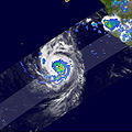
Hurricane Paul, the 10th hurricane of the season in the East Pacific, began as a tropical depression (area of unusually low air pressure at the ocean surface) during the early morning hours of October 21, 2006 (local time), about 265 miles south-southwest of Manzanillo, Mexico. Paul reached hurricane intensity on the afternoon (local time) of October 22.

The Tropical Rainfall Measuring Mission (TRMM) satellite captured this image of Paul at 5:15 p.m. Pacific Daylight Time on October 22 (00:15 UTC, October 23), as the storm was transitioning from a tropical storm into a hurricane. The image is a top-down view of where the heaviest rain was occurring. Rain rates in the center of the swath come from the TRMM Precipitation Radar, while those in the outer swath are from the TRMM Microwave Imager. These rain rates are overlaid on infrared data from the TRMM Visible Infrared Scanner.

A small eye is visible near the center of the storm, with several moderate-intensity bands of rain (green arcs) spiraling inward from the south. These rainbands are the tell-tale signs of a developed circulation. Scattered areas of heavy rain (shown in red) are also evident, including one in the storm’s eyewall (central ring of clouds) just to the east of the center. At the time of this image, the National Hurricane Center (NHC) estimated Paul had sustained winds of 55 knots (63 miles per hour). Paul became a hurricane just a few hours later.

From its low-earth orbit, TRMM has been providing valuable images and information on tropical cyclones around the Tropics since 1997, especially over open ocean where direct observations are limited. TRMM is a joint mission between NASA and the Japanese space agency, JAXA.
Fecha
Fuente http://earthobservatory.nasa.gov/NaturalHazards/natural_hazards_v2.php3?img_id=13940
Autor NASA images by Hal Pierce (SSAI/NASA GSFC), and caption by Steve Lang (SSAI/NASA GSFC).
Permiso
(Reutilización de este archivo)
Public domain Este archivo es de dominio público porque fue creado por la NASA. Las políticas sobre copyright de la NASA estipulan que «el material de la NASA no está protegido con copyright a menos que se indique lo contrario». (Políticas sobre copyright de la NASA o Políticas sobre la utilización de imágenes del Jet Propulsion Laboratory).
Advertencias:
  • El uso del logotipo de la NASA (incluidos el logotipo actual y los anteriores) está restringido.
  • El sitio web de la NASA almacena una gran cantidad de imágenes del Programa Espacial de la URSS, de la Agencia Espacial Federal Rusa y otras agencias espaciales no estadounidenses. Estas imágenes no son de dominio público.
  • Material del Telescopio espacial Hubble puede tener copyright si no proviene explícitamente del Space Telescope Science Institute. [1]
  • Todo el material creado por la sonda espacial SOHO está protegido por copyright y requiere permiso para ser utilizado con fines comerciales o no educativos. [2]
  • Las imágenes que figuran en el sitio web Astronomy Picture of the Day (APOD) pueden tener copyright. [3]

Leyendas

Añade una explicación corta acerca de lo que representa este archivo

Elementos representados en este archivo

representa a

image/jpeg

Historial del archivo

Haz clic sobre una fecha y hora para ver el archivo tal como apareció en ese momento.

Fecha y horaMiniaturaDimensionesUsuarioComentario
actual03:12 27 oct 2006Miniatura de la versión del 03:12 27 oct 20061024 × 1024 (479 kB)A7xHurricane Paul, the 10th hurricane of the season in the East Pacific, began as a tropical depression (area of unusually low air pressure at the ocean surface) during the early morning hours of October 21, 2006 (local time), about 265 miles south-southwest

La siguiente página usa este archivo:

Uso global del archivo

Las wikis siguientes utilizan este archivo:

Metadatos