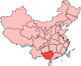
Archivo:China-Guangxi.png
China-Guangxi.png (268 × 218 píxeles; tamaño de archivo: 31 kB; tipo MIME: image/png)
Historial del archivo
Haz clic sobre una fecha y hora para ver el archivo tal como apareció en ese momento.
| Fecha y hora | Miniatura | Dimensiones | Usuario | Comentario | |
|---|---|---|---|---|---|
| actual | 18:12 28 oct 2007 |  | 268 × 218 (31 kB) | Croquant | transparent background |
| 22:35 4 jun 2005 |  | 268 × 218 (9 kB) | Ran | '''en''': Location of Guangxi Zhuang Autonomous Region in the People's Republic of China. See Category:Locator maps of province-level divisions of the People's Republic of China for more information. '''zh''': 廣西壯族自治區在中華人民共 |
Usos del archivo
La siguiente página usa este archivo:
Uso global del archivo
Las wikis siguientes utilizan este archivo:
- Uso en ast.wikipedia.org
- Uso en da.wikipedia.org
- Uso en de.wikipedia.org
- Liuzhou
- Guilin
- Vietnamesen
- Mandschu
- Han (Ethnie)
- Hakka
- Hui-Chinesen
- Zhuang
- Nanning
- Wuzhou
- Yao
- Dong (Volk)
- Yi (Volk)
- Sui (Volk)
- Gelao
- Mulam
- Maonan
- Gaoshan
- Beihai (Guangxi)
- Yulin (Guangxi)
- Guigang
- Vorlage:Navigationsleiste Bezirksebene Guangxis
- Bose (Guangxi)
- Chongzuo
- Fangchenggang
- Hechi
- Hezhou
- Laibin
- Qinzhou
- Miao
- Vorlage:Navigationsleiste Nationalitäten in Guangxi
- Uso en en.wikipedia.org
- Haicheng District
- Tieshangang District
- Yinhai District
- Sanjiang Dong Autonomous County
- Wikipedia:WikiProject Chinese provinces/Locator maps
- Chengyang, Guangxi
- Shoumei tea
- Yingpan, Guangxi
- Seven-star Cave
- Yizhou District, Hechi
- Longzhou County
- Pingxiang, Guangxi
- Yu River (Guangxi)
- Yongfu County
- Lingui District
- Kunlun Pass
- Rong River (Guangxi)
Ver más uso global de este archivo.

