Archivo:Agricultural Fields near Perdizes, Minas Gerais, Brazil.JPG

Tamaño de esta previsualización: 800 × 532 píxeles. Otras resoluciones: 320 × 213 píxeles · 640 × 425 píxeles · 1024 × 681 píxeles · 1280 × 851 píxeles · 2560 × 1701 píxeles · 4288 × 2850 píxeles.
Ver la imagen en su resolución original (4288 × 2850 píxeles; tamaño de archivo: 2,83 MB; tipo MIME: image/jpeg)
Resumen
| Descripción |
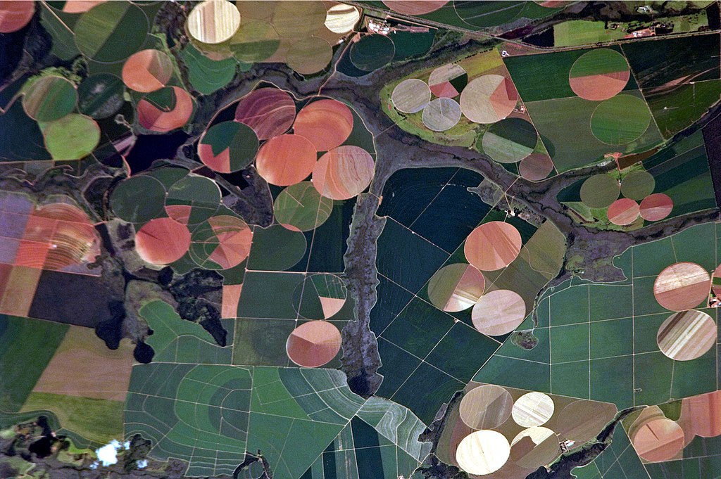
English: This astronaut photograph illustrates the diverse agricultural landscape in the western part of Minas Gerais state in Brazil. The fields in this image are located south-west of the city of Perdizes, which means “partridges” in Portuguese. A mix of regularly-gridded polygonal fields and circular centre-pivot fields marks the human use of the region. Small streams (and their adjacent floodplains) of the Araguari River extend like fingers throughout the landscape. – The visual diversity of the field forms is matched by the variety of crops: sunflowers, wheat, potatoes, coffee, rice, soybeans, and corn are among the products of the region. While the Northern Hemisphere is still in the grip of winter, crops are growing in the Southern Hemisphere, as indicated by the many green fields. Fallow fields—not in active agricultural use—display the violet, reddish, and light tan soils common to this part of Brazil. Darker soils are often rich in iron and aluminum oxides, and are typical of highly weathered soil that forms in hot, humid climates. |
| Fecha | |
| Fuente |
English: NASA Earth Observatory – Image acquired with a Nikon D2Xs digital camera using an 800 mm lens, and is provided by the ISS Crew Earth Observations experiment and Image Science & Analysis Laboratory, Johnson Space Center. |
| Autor | ISS Expedition 26 crew |
| Posición de la cámara | | Ubicación de esta y otras imágenes en: OpenStreetMap |
|---|
Este archivo fue catalogado por Johnson Space Center de la Administración Nacional de Aeronáutica y del Espacio (NASA) de los Estados Unidos de Américabajo el identificador de foto: ISS026-E-25373.Esta etiqueta no indica el estado de los derechos de autor del trabajo adjunto. Se requiere una etiqueta de derechos de autor normal. Para más información vea Commons:Sobre las licencias. Otros idiomas:
|
Licencia
"The Gateway to Astronaut Photography of Earth". Imagen cortesía de Image Science & Analysis Laboratory, NASA Johnson Space Center.
Fuente de la foto: ISS026-E-25373.
|
| Annotations | This image is annotated: View the annotations at Commons |
Historial del archivo
Haz clic sobre una fecha y hora para ver el archivo tal como apareció en ese momento.
| Fecha y hora | Miniatura | Dimensiones | Usuario | Comentario | |
|---|---|---|---|---|---|
| actual | 17:46 15 dic 2014 | | 4288 × 2850 (2,83 MB) | ArionStar | Reverted to version as of 12:59, 21 February 2011 |
| 14:38 10 dic 2014 |  | 2629 × 1994 (1,1 MB) | ArionStar | Lower resolution but better quality | |
| 14:30 10 dic 2014 |  | 2616 × 2028 (1,14 MB) | ArionStar | Lower resolution but better quality | |
| 12:59 21 feb 2011 |  | 4288 × 2850 (2,83 MB) | Originalwana | {{Information |Description ={{en|1=This astronaut photograph illustrates the diverse agricultural landscape in the western part of Minas Gerais state in Brazil. The fields in this image are located south-west of the city of [[:Category:Perdizes|Perdize |
Usos del archivo
La siguiente página usa este archivo:
Uso global del archivo
Las wikis siguientes utilizan este archivo:
- Uso en bg.wikipedia.org
- Uso en el.wikipedia.org
- Uso en en.wikipedia.org
- Uso en eu.wikipedia.org
- Uso en fr.wikipedia.org
- Uso en nl.wikipedia.org
- Uso en pt.wikipedia.org